Product has been added to the basket

Ithaca theory gains support

Test borehole drilled to a depth of 122m (400 feet) to determine whether surface rockfall continues below sea level

Geoscientist 17.2 February 2007

Results of an offshore seismic survey and the first borehole to test the hypothesis that the Paliki peninsula of the Greek island of Kefallinia was once Homer's Ithaca lend weight to the theory. Ted Nield reports

The theory that the home of Odysseus, which has never been satisfactorily identified, was in fact a part of the modern island of Kefallinia that was once an island in its own right (Geoscientist 16, 9 p4 et seq.) has received support from the first test borehole. 

The theory, advanced by British businessman Robert Bittlestone (author of Odysseus Unbound - the search for Homer's Ithaca - Cambridge University Press), with Cambridge University classicist, Professor James Diggle and Edinburgh University geologist, Professor John Underhill, predicts that the peninsula of Paliki was once separated from the rest of Kefallinia by a narrow, probably tidal channel that subsequently became blocked by landslips. This theory solves a number of disagreements between modern geography and Homer's text - inconsistencies not satisfied by the assumption that Bronze Age Ithaca and the modern island of Ithaki (to the east of Kefallinia) were one and the same island.

In October 2006 a 122-metre borehole was drilled at the southern end of the isthmus between Kefallinia and its western peninsula (Paliki) to see if the drill-bit encountered solid in situ bedrock or loose rockfall. As predicted by the theory, the drill encountered substantial amounts of loose material in the upper sections of the borehole. Underhill told reporters: "The location of this borehole was chosen to represent a demanding test of the theory. It is about 350m from where we have diagnosed the likely southern exit of the buried sea channel, and to its east and west there is solid limestone mountainside.
"Significantly we drilled to … almost 15m below today's sea level, and we didn't meet any solid limestone strata at all. Although this is a first step in testing whether or not this whole isthmus was once under the sea, it is very encouraging confirmation of our geological diagnosis derived from surface observations collected during fieldwork … over the past three years."

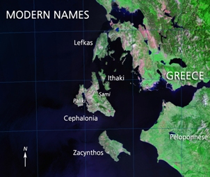
If the peninsula of Paliki was a free-standing island 3200 years ago, it would exactly match Homer's description of Odysseus's Ithaca, solving a classical enigma that has puzzled scholars for thousands of years and explaining why no convincing archaeological evidence of Odysseus's palace has ever been found on modern Ithaki. It also would concur with the description of the area by the ancient geographer Strabo, who wrote "where the island is narrowest it forms an isthmus so low-lying that it is often submerged from sea to sea".

Further support also comes from a marine seismic and bathymetric survey of the enclosed gulf to the south of where "Strabo's Channel" is inferred to have lain. Conducted jointly by Professor Underhill and a team from the Athens-based national geological institute (IGME) led by Dr Constantine Perissoratis, these surveys have confirmed the existence of a distinctive offshore marine valley about 28m deep that lines up perfectly with that point on the coast where Strabo's Channel is inferred to have had its southern exit.

Prof. Underhill now thinks he understands how this valley may have formed, and how the channel became obliterated over the last 3000 years. "At the time of the last main interglacial, about 125,000 years ago, sea-levels were at a similar or slightly higher level than today. From there, sea-level dropped worldwide by about 120m over the next 100,000 years or so to reach their lowest point around 21,500 years ago during the last glacial maximum."

Although ice never reached Greece, sea-levels began to recover as the ice-caps melted in higher latitudes. "Marine waters reached the upper part of the gulf as recently as 5000-6000ka years ago" says Underhill, “after the enhanced upstream erosion that took place due to the lowering of local base levels. It is this rise that may have enabled the sea to connect right through the Thinia Valley."

“The narrow seaway sowed the seeds of its own destruction since the sea would have begun to destabilise the soft Miocene marl sidewalls of the channel, causing periodic slumps that would have blocked access unless they were dredged clear by human intervention" Underhill says. "The landscape evolution now envisaged is therefore consistent with Strabo's unusual observation that the sea "often" penetrated the narrowest part of the island from coast to coast - these intermittent slumps may have been the reason why marine inundation was described as occurring occasional rather than permanent."

Underhill thinks that eventually, earthquake-induced failure of the eastern mountainside later caused catastrophic rockfalls many magnitudes more potent. He believes that massive submarine sediment piles thatthe team have also identified on the seismic data were derived from mountains to the east of the Gulf. "There is an ever increasing probability that it was these rockfalls that led to the two former islands being joined together to make the single landmass we see today."

Gravity surveys conducted on land across the site of the proposed channel also support the hypothesis, revealing low-density material in the area designated as channel fill. Further drilling, including the cutting of continuous cores, is planned during 2007. Further updates will appear in Geoscientist later in the year to keep readers up-to-date with geoscientific discoveries as and when they are made. 

Odysseus Unbound Website