John Dixon looks at the World Heritage Site of Machu Picchu (Peru) with the eye of an engineering geologist
 As he forced his way through the forests of south eastern Peru a little over 100 years ago Hiram Bingham would not have believed the find he was about to make, or the interest that it would generate. Today, his discovery - Machu Picchu - has to be limited to 2500 visitors per day, all of whom gaze in awe at works that, when Bingham first saw them, were covered by thick forest.
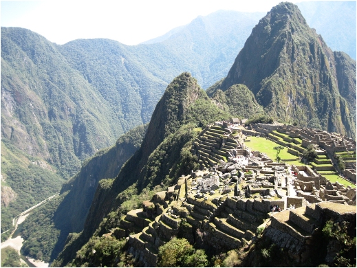
Picture: The Citadel of Machu Picchu. The Rio Urubamba on the bottom left and Huayna Picchu on the top right.
Yet the site is as breathtaking for the engineering feat required to put it there as it is for the beauty of its location. After it was finally abandoned Machu Picchu remained undisturbed for 500 years. Yet in choosing the site for its very remoteness (to hide what proved to be one of their last cities from Spanish invaders) the Inca set themselves some fearsome engineering challenges.
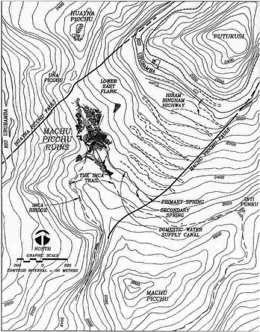
Machu Picchu (or ‘Old Mountain’) stands at a little over 2400m above sea level. It is - or was - an almost conical block of granite, part of the Permo -Triassic Vilcabamba Batholith. The rock is a light-coloured biotite-granite with a composition typically given as 60% feldspar, 30% quartz and the rest biotite and accessory minerals. Structurally, it is a fault block controlled by movement along the Machu Picchu and Huayna Picchu (‘Young Mountain’) faults that run to the north and south of the citadel.
Río Urubamba
 These faults define a graben structure which has slowly settled over geological time and on which the ruin now rests. The faults are easy to spot from the vantage point of the crest, since planar features corresponding to them can be seen on the adjacent hills across the valley of the Río Urubamba. The river forms an incised meander that has been controlled by both the faulting and jointing in the biotite granite. This lends spectacle to the scene and makes approaching the citadel difficult today, even with modern modes of transport – in Bingham’s day merely crossing the river was something of a logistical nightmare.
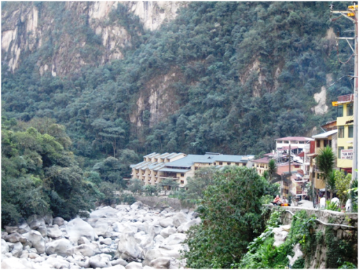
Picture: The misfit Rio Urubamba as it passes through the town of Aguas Calientes
The Río Urubamba is a very vigorous river, transporting large blocks of the local rock in times of flood, and upstream of Aguas Calientes this is still the case. Nowadays however the advent of hydro electricity some few miles south of the town means that for a large stretch of its course the river is a ‘misfit’, flowing gently now between the ancient bed load, accumulated during its previous activity and still abundantly obvious. Nevertheless as the river follows the meander around Huanya Picchu and Machu Picchu mountains it picks up incoming streams from these hills, replenishing much of the water lost to hydro-power in its upper reaches.
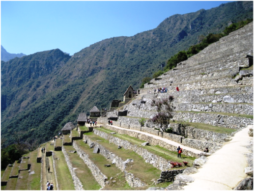 Picture: Agricultural terracing on the south side of Machu Picchu.
The hills in this area of so-called ‘Cloud Forest’ are steep - and as such they tend to be prone to mass wasting and landsliding. The Río Urubamba cuts through several large debris flows on it its way into Aguas Calientes, where jumbles of material (ranging from large boulders to sand) can be seen in steep cliffs rising perhaps 20 metres above the river. The slopes immediately below the citadel of Machu Picchu are prone to rock slides, and at the time of visiting (August 2014) remedial work was underway along the access road to the site, known as Hiram Bingham Highway.
The rock slide comprised substantial blocks of granite and finer granitic material together with forest debris and affected about 200m (vertically) of the slope. It appears that the slip was governed by the major joint sets in the granite which possibly suggests wedge or planar failure. This is a continuous maintenance problem for the site, because without the access road there would be no chance for most tourists to visit it unless they were prepared to spend four days hiking the Inca Trail to reach it. It did not seem to me that any major preventive engineering works had been carried out to control or remedy such slips. I observed no evidence of anchors or buttressing or rock fall netting or any of the features you might expect in comparably fall-prone areas of Europe or North America. There is however, strong emphasis on drainage - which in an area where annual rainfall can be 2000mm probably lies behind all slope stability issues.
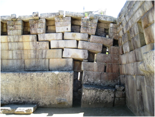
Citadel
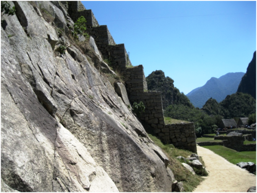 Picture: Retaining structures of the residential areas of Machu Picchu.
The citadel of Machu Picchu is an unlikely marvel, since to achieve its construction the Incas reshaped the mountain, levelling off the crest, or rather the ridge, between Machu Picchu and Huayna Picchu, and using much of the resulting rock in construction. Even humble houses and storerooms are stone built – everything is in stone. Perhaps the most remarkable feature, however, are the ever-present retaining walls.
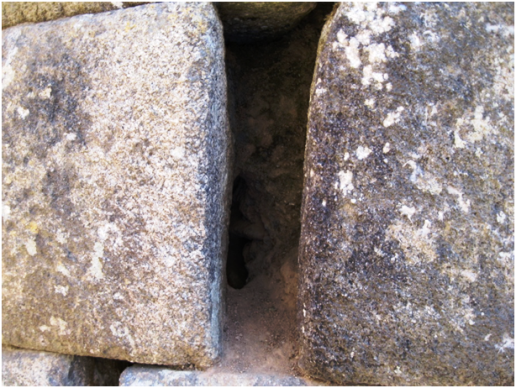
Inca terracing is a common feature in much of Peru, where it was used for agricultural purposes. Here in Machu Picchu that is still the case for some terracing in the southern sector of the citadel but a large portion of the terracing elsewhere was created for purely structural purposes. The well-jointed granite has been quarried at the crest and formed in to blocks to provide material for tier upon tier of dry stone walls which effectively hold the citadel in place. It would appear also that the Incas were aware of the effects of increased water pressure behind structures such as this, for there is clear evidence that they created weep-holes to allow water to drain from behind the structures and so encourage long-term stability.
It is also known that Inca agricultural terraces were filled with different types of material, with coarse gravels being used at the base and then sands until finally a layer of good soil finished off the profile. Such care clearly demonstrates a thorough knowledge of the need to control water. Throughout the site there is evidence of efficient drainage measure to control the torrents of rain that can fall. As recently as January 2010 rainfall in the area was so heavy that landslips and flooding caused the closure of the site for almost three months. However, the Inca drainage works at the crest prevented any large-scale damage to the ancient monument itself.
 Picture: Stone-built cavity walls with mud infill to act as seismic dampening.
The area of Machu Picchu is not especially known for seismic activity but the Incas were well aware of earthquakes from their experience in other cities in the region, such as the capital (Cusco, in south eastern Peru), and when it came to building large structures on a steep hillside it must have seemed obvious to them to incorporate earthquake-related engineering into the design.
At Machu Picchu, Inca seismic engineering skills are demonstrated in a number of ways. In the first place the stone walls are not all solid - they comprise two walls of stone with what would be termed a cavity between except that this cavity is filled with mud. This is considered to be a good method for damping the effects of all but the largest earthquakes. There are clear examples of this approach in many parts of the site.
Anyone who knows anything about Inca building will be familiar with their monumental architecture with its wonderfully cut and fitted large stone blocks. This type of architecture was generally reserved for buildings of considerable importance - for instance, temples. For sites in seismic zones the Inca prepared for earthquakes by constructing a slope into these walls of about 15 degrees. At Machu Picchu they adopted a similar approach – except, realising no doubt that the region was less earthquake-prone, they were able to reduce the inclination of the walls to about seven degrees. Not only were the Inca aware of seismic activity, they seemed to have recognised at a relatively early stage that earthquakes were not the same in all areas of their empire and adjusted their methods to take account of this fact. In addition to these measures it is also known that the Inca founded large monumental blocks on a layer of smaller, shaped blocks - perhaps about the size of a brick. This is also considered as an earthquake-dampening measure, allowing Inca structures to escape all but the most severe tremors.
Collapse
 Picture: The temple enclosure at Machu Picchu showing differential settlement of the northeast corner.
However, not everything in the Inca world was perfect – as is clearly shown by the temple enclosure in Machu Picchu. Here, in a three-sided monumental structure, the finely worked granitic blocks to the immediate east of the altar stone are in a state of collapse. On the basis of available information it would appear that the north-east corner of the enclosure has been subjected to half a millennium of differential settlement - which perhaps suggests that even though they were prodigious engineers, ground investigation was maybe not their strong point.
Machu Picchu and its surroundings is a UNESCO World Heritage site and there can be little doubt that it well deserves this status. The site holds much of interest for scientist and engineers of all sorts and while problems with the steep hillsides, which in the past have lead some scientist to give dire warning of collapse it would seem that the biggest danger to the site these days comes from the enthusiastic tourist who wants to get the best shot or the silliest “selfie”- it is the control of tourism that will present the biggest challenge to generations to come a challenge almost as big as that faced by the Incas who first dreamed of building such a citadel.
* Dr John Dixon is a consulting engineering geologist, currently based in Lima, Peru.
 References
- Wright, K, Valencia, A, and Loran, W L (undated). Ancient Machu Picchu Drainage Engineering. www.waterhistory.org
- Ziegler, G R (undated) Machu Picchu, Stable as a Rock, a Geological Review.