Jenny Ellis and Roddy Muir* describe how a team of climbers, botanists and geologists undertook a radical new survey of Britain’s highest mountain
 Ben Nevis is Britain’s highest mountain, rising 1344 metres above sea level. Commonly referred to as ‘the Ben’, it looms large over Fort William in the Northwest Highlands of Scotland. Hill walkers usually approach it from the south side in Glen Nevis via a well-graded track; but the north side of the mountain is a set of spectacular 600m cliffs, gullies and buttresses, collectively known as the North Face.
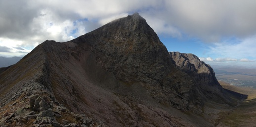
Picture: The North Face of Ben Nevis from the Carn Mor Dearg Arete. The contact between the Inner Granite (pale pink rocks in the foreground) and the dark volcanic rocks which form the North Face and summit area of the mountain can be traced from the top left of the ridge down into Coire Leis and then along the U-shaped valley of the Allt a’ Mhuilinn to the west (Photo: R. Muir).
Geologists, botanists, meteorologists, and mountaineers have been drawn to this unique location for more than two centuries, yet much of this Site of Special Scientific Interest (SSSI) has remained inaccessible because of steep terrain and hostile weather.
In 2014, over a single August fortnight, a team of scientists and mountaineers undertook one of the most extensive and logistically challenging surveys ever conducted on a Scottish Mountain. Aided by nearly 3000 metres of rope and using special low-impact mountaineering techniques, the team safely gathered new data on the Ben’s geology and botany from previously unexplored areas of the North Face.
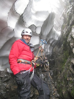
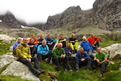 Picture: Professional Climbers, Geologists and Botanists in the North Face Survey team (Photo: D. MacLeod)
Mike Pescod, a British Mountain Guide, explained: “The main logistical challenge was keeping the scientists safe while also ensuring minimal impact on the fragile habitats within the SSSI. During the training session we developed an ecologically light-touch approach which incorporates mountain rescue systems alongside alpine and big-wall climbing techniques”. What this meant, among other things, was that no fixed anchors were placed in the rock, and no geological or botanical samples could be collected by the survey teams.
The mountaineers also brought an extensive and detailed knowledge of the mountain to the scientific survey. We expect that the climbing techniques employed by the survey will be endorsed by the Association of Mountaineering Instructors and become the recommended approach for similar scientific surveys in mountain regions.
Early science on the Ben
The first recorded ascent of Ben Nevis was in 1771, by botanist James Robertson on an expedition to collect plant specimens for the College Museum of Edinburgh. A few years later in 1774, geologist John Williams also visited, to assess whether there were any minerals of commercial value around the summit.
The Scottish Meteorological Society occupied the summit observatory for almost 21 years from November 1883, and made hourly observations - until a lack of government funding forced the operation to close in 1904. Those 20 years’ worth of information still constitutes the most comprehensive set of mountain weather data ever recorded in Britain, as the automated recording equipment used today is not robust enough to withstand the extreme conditions encountered on Scottish mountaintops. The Ben’s height is hardly alpine in scale, but its northerly latitude, steep cliffs and north-facing aspect give rise to a local climate that is comparable to many arctic-alpine regions.
The first systematic geological survey of the Ben Nevis area was carried out by Herbert Brantwood Maufe in the early 1900s and the Geological Survey of Great Britain published the first edition of the geological map (sheet 53) and accompanying memoir in 19161,2. The early survey workers recognised three principal lithologies arranged concentrically around the mountain, namely: (1) Outer Granite, (2) Inner Granite, and (3) volcanic rocks forming the North Face and summit.
Picture: Geological map and cross section of Ben Nevis after Bailey and Maufe (1916)
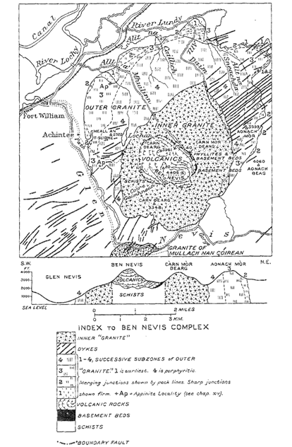
The Inner Granite displays chilled margins against both the Outer Granite and the volcanic rocks on the North Face and is clearly the youngest of the three. We now know from isotope dating that the Ben Nevis igneous complex is Late Silurian/Early Devonian in age3 and are intruded into late Precambrian metasedimentary rocks of the Dalradian Supergroup.
Maufe and Bailey & Maufe interpreted the central volcanic rocks as a down-faulted block, and the geology of the Ben Nevis area is widely quoted in the published literature as a classic example of caldera subsidence where a central volcanic complex has collapsed on a circular ring fault into the underlying magma chamber. The survey workers described a narrow band of “flinty crush rock” separating the inner granite from the volcanics and suggested that this formed by intense mechanical shearing at the edge of the volcanic pile as it descended into the underlying granitic magma chamber. More recently Burt & Brown4 have interpreted the flinty crush rock as a flow-banded ignimbrite, which formed a conduit for magmatic material during caldera collapse.
Surprisingly, there are no published data on the orientation of any geological contacts, flow features or bedding within the main mass of volcanic rocks at Ben Nevis. In addition, the contact between the Inner Granite and the volcanics in the Allt a’ Mhuilinn is described as near vertical or steeply dipping (both to the east and west), although in all cross-sections produced by the Survey it is shown as a contact dipping at less than 45° to the south underneath the North Face.
The North Face Survey
A new scientific survey of the North Face was originally conceived by Scottish Natural Heritage in collaboration with the Nevis Landscape partnership, with the aim of documenting the distribution of the rare arctic-alpine flora found on Ben Nevis. Some of the key locations already known about are at risk from damage through recreational activity (climbing and walking), but are also potentially threatened by changing climate.
Lead survey botanist, Ian Strachan, explains: “Many of the rare Artic-Alpine species ... are relics from the last Ice Age. Ben Nevis provides the most southerly refuge for some of these species, which can only survive due to the altitude and presence of semi-permanent snow fields. It is therefore essential for us to record the presence and abundance of this flora, so we can develop an effective preservation management plan.”.
 Picture: Wavy Meadow Grass (Poa flexuosa) on the North Face (Photo: D. MacLeod).
While we were about collecting this information, we felt that the survey would also provide an ideal opportunity to gather new geological data too. And so our employer, Glasgow-based structural geology company Midland Valley, which had already used the Ben as a testing ground for their new digital field mapping technology, offered to assist.
Team, Techniques and Technology
The survey team consisted of 10 professional mountaineers, two botanists and two geologists. Before heading onto the mountain the team spent a week sharing their knowledge. Day one began at the Lochaber Mountain Rescue Training facility, just outside Fort William, and the scientists were coached in core skills such as abseiling and the use of fixed hand-lines. Many of the sites of interest to the botany team were known to be very damp in summer (‘flush’ areas).
These locations, gullies, often coincide with closely spaced joint systems or faults and are full of loose, wet rock. Climbers tend to avoid such places. In contrast, geologists (while keen to look into deep gullies and river beds) are also looking for the steepest, hardest rock with good planar joint systems and geological contacts, where reliable structural measurements can be taken. Fortunately, we managed to strike a good balance between the differing needs of these groups.
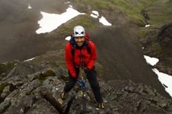
Picture: Geologist Roddy Muir prepares to abseil 200m down the front face of The Comb (Photo: D. MacLeod).
 The training week continued with introductions to the geology and botany of the Ben Nevis area for the benefit of the climbers. It was important to recognise that the climbers who took part in the survey will act as ‘landscape champions’, their new knowledge providing a novel slant to their professional mountain-guiding activities. Increased knowledge of geology and botany will help to minimise the impact of recreation on the mountain environment, hopefully encouraging wider stewardship of the landscape as information cascades down to the general public.
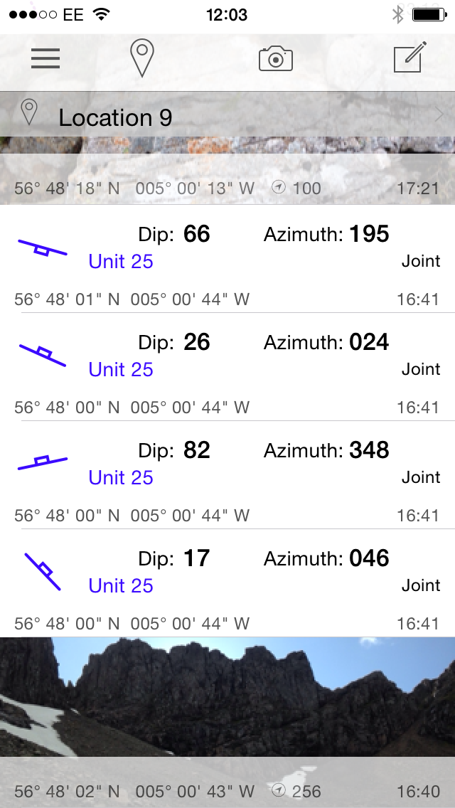
Climbers, botanists and geologists were all trained to gather data on iPhones using Midland Valley’s Clino application. This contains a digital compass clinometer, map, notebook and camera in a single application - a complete mapping system for geologists in one device. As well as setting up a project to gather information on the geology, the app can be used to make notes, photograph plant specimens and record their location using the phone’s internal GPS.
We knew the app already of course, but we were impressed and pleased at how quickly the climbers and botanists were able to pick it up. Their data added significantly to the reliable information that we were able to gather during the survey. Data collected by the climbing teams, surveying without an expert botanist or geologist present, could be checked in the evening in the mountain hut and if necessary an expert could return to verify the discovery on the following day.
After a winter of record snowfall the mountain still had a distinctly alpine feel. Snowfields remained in the gullies and scattered around the higher screes. These had compacted into dense, ice-hard névé - first stage in glacier formation. Sheets weighing hundreds of tons, with tunnels and fissures (bergschrunds) presented further challenges. Such hazards, common in arctic and alpine environments, are extremely unusual during a British summer.
Picture: Compacted and dense névé in a gully on the North Face - extremely unusual at this time of year (Photo: D. MacLeod).
 The weather during the survey was mixed, with the tail-end of hurricane Bertha passing over Scotland during August’s second week. Winds of over 100mph, more than 10cm of rain in 24 hours and sub-zero temperatures at the summit made for challenging climbing conditions. This emphasised the fact that traditional surveying techniques (with paper maps, notebooks, pencils and cameras etc.) would not have been practical in these conditions, especially on some of the 200m abseils. But you do need a waterproof case for your smart-phone!
Botany on the Ben
The botanical survey focused on nationally rare and scarce species, and many new populations of grasses and saxifrages were observed and recorded. Identification was aided by a helpful library of photographs, loaded before starting the survey. By the end of the week the team had more than doubled the number of known areas holding rare species on the mountain, such as the Tufted Saxifrage (Saxifraga cespitosa), Drooping Saxifrage (Saxifraga cernua), Arctic Mouse Ear (Cerastium cerastoides) and Wavy Meadow grass (Poa flexuosa). Two new locations for Alpine Saxifrage (Saxifraga nivalis), previously unknown on the North Face, were also found and the discovery of Wavy Meadow Grass high up in a gully on Trident Buttress is a new UK altitude record.
Great care was taken not to disturb any plant specimens during the survey and the decision was taken not to use some of the more commonly used descent routes so that the flora would remain un-trampled during the main flowering season. The botanical information is currently being analysed in more detail and the data will be incorporated in a 3D geological model of the North Face being constructed (by Midland Valley geologists). Combining geological and botanical data in one model will enable the team to reveal any direct links between the flora and underlying rocks.
Geology on the Ben
When Midland Valley was testing its digital mapping technology on Ben Nevis (and various sites around Glencoe) it quickly became apparent that the distribution of rock types originally mapped by the Survey on more accessible parts of the North Face (particularly in Coire na Ciste above the CIC hut) was incorrect in detail. The team have therefore been using the project to remap the area, focusing more closely on the orientation of geological contacts, igneous and sedimentary layering, and structural features such as joints systems and faults.
Picture: Screenshot from Midland Valley’s Clino app (notebook pages) showing examples of geological data gathered during the survey (Images from Clino © Midland Valley).
At the end of the Survey we had collected nearly 600 structural readings, and for the first time it has been possible to measure the orientation of magmatic flow features within the central volcanic rocks. Sedimentary rocks thought to be similar to modern-day playa-lake deposits are inter-bedded within the volcanic sequence and we have been able to measure the dip and strike of bedding in these units.
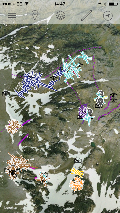
The next step will be to construct a 3D model of the Ben, combining the new data and a digital elevation model using Midland Valley’s Move software. Having orientation data on igneous and sedimentary layering means we will be able to restore the data to its original orientation at time of deposition/emplacement. It is still early days but preliminary results indicate that the traditional model of caldera collapse on a circular ring fault surrounding the central volcanics may have to be revised.
What next?
Picture: New structural data projected onto a digital elevation model of the North Face of Ben Nevis in Midland Valley’s Move software (Move image © Midland Valley).
 The 2014 survey concentrated on the central part of the North Face on the cliffs, gullies and buttresses surrounding Coire na Ciste, and will continue with further surveys in 2015 and again in 2016. A summary of the findings from year one can be found online at
www.abacusmountaineering.com/North%20Face%20Survey%20Project%20Report%202014.pdf
The new data will be mapped onto an interactive 3D model of Ben Nevis that will be widely distributed throughout the scientific community and through various public channels. The whole project is being filmed and documented by the Scottish climber Dave MacLeod and will be premiered at the Fort William Mountain film festival, held in February every year (www.mountainfestival.co.uk/).
Acknowledgements
The North Face Survey is being co-ordinated by the Nevis Landscape Partnership (NLP), a charitable trust set up in 2003 to help guide and manage opportunities for visitor enjoyment and appreciation of the wider Nevis Area. Funding for the project was kindly provided by the Heritage Lottery Fund, Scottish Natural Heritage (SNH) and the Highland Council. We would particularly like to thank Tristan Semple, Project Manager of the NLP and Cathy Mayne from SNH for their support and encouragement during the survey. Support has also been provided by Midland Valley and the outdoor equipment manufacturer Mammut.
Access to the North Face would not have been possible without the skill, energy and enthusiasm of the professional climbers involved in the survey: Mike Pescod, Donald King, Alan Halewood, Scott Kirkhope, David Buckett, Dave Anderson, Will Roland, Connor Holdsworth, Andy Hague and Edward Holt. Noel Williams and Rod Burt kindly provided unpublished background information on the geology of the Ben that greatly helped during the new survey. We would also like to thank Ian Strachan and Gordon Ogilvie for sharing their botanical knowledge with the entire team.
References
- Maufe, H. B. (1910) The geological structure of Ben Nevis. Geological Survey of the United Kingdom, Summary of Progress for 1909, pp. 80–9.
- Bailey, E. B. and Maufe, H. B. (1916) The geology of Ben Nevis and Glen Coe and the surrounding country, 1st edn. Memoir of the Geological Survey of Great Britain, Sheet 53 (Scotland).
- Thirwall, M. F. (1981) Implications for Caledonian plate tectonic models of chemical data from volcanic rocks of the British Old Red Sandstone. J. Geol. Soc. London, 138, 123 – 138.
- Burt, R. M. and Brown, P. E. (1997) The Ben Nevis Intrusive Ring Tuff, Scotland: reinterpretation of the ‘flinty crush rock’ as part of an ignimbrite conduit in the roots of an ancient caldera. Scottish Journal of Geology, 33, 149–55.
Links
*Midland Valley, 2 West Regent Street, Glasgow, G2 1RW. For more about Move software, visit www.mve.com.