 Graham Leslie* and Mike Browne** explore the opportunities that can be built on the legacy of Scotland’s Opencast coal.
Starting from small-scale 13th Century operations, coal mining in Scotland expanded slowly until the 18th Century when, with the onset of the UK Industrial Revolution, steam engines created a near insatiable demand for fuel. Much of Scotland’s industrial growth and prosperity in the late 18th to mid-20th Centuries depended upon the extensive exploitation of Central Scotland’s Carboniferous coal, in concert with ironstone, oil-shale, limestone, sandstone, fireclay and mudstone (the last for brick-making).
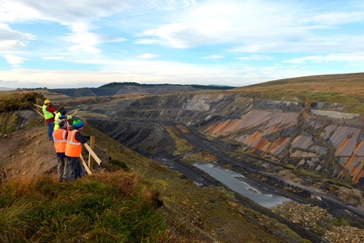
Picture: The 80-85m deep Spireslack ‘canyon’ can host a wide spectrum of new research in a volume of rocks where the essential stratigraphic and structural architecture is already well understood.
From a peak of just under 240 million tonnes of coal produced in 1905 when Great Britain was for a time the world’s largest producer, coal production and the workforce have declined dramatically. The announcement in 2015 of the final closure of Kellingley Colliery in North Yorkshire saw an end to deep mining of coal in the UK. Although underground working ceased in Scotland in 2002, a third of UK opencast coal production took place in surface mines across Central Scotland up until 2010. Since then, weak world coal prices and other issues precipitated the financial collapse of two major operators of Scottish opencast coal sites.
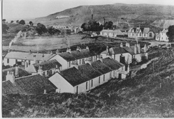 Picture: Glenbuck village, Ayrshire, c. 1920.
A whole generation of Scots has arguably lost touch with the coal that provided employment, income, energy and a social structure for their parents, grandparents and older generations. Mining communities created a strong socialist heritage in many parts of the country; James Keir Hardie, founder of the Labour Party, lived in nearby Cumnock for much of his life. Bill Shankly, arguably Liverpool FC’s most famous manager, hailed from the mining community that lived, worked and played in the village of Glenbuck. The local Glenbuck Cherrypickers football team achieved fame as a source of some 50 professional football players until the club was disbanded in 1931, as the local Grasshill Pit closed for the final time and underground mining ended (the young Shankly never played for the first team it seems!).
Liquidation
 In April 2013, Scottish Coal went into liquidation, leaving seven ‘orphaned’ sites, all lacking the necessary funding for ‘muck shift and levelling’ restoration programmes that would have involved the opencast excavations being backfilled with waste bedrock material. In response, and at the behest of the Scottish Government, the Scottish Mines Restoration Trust (SMRT) set out to facilitate communities and other stakeholders in bringing together viable restoration/redevelopment plans for these orphaned opencast sites.
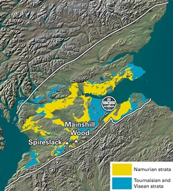
Picture: Mainshill Wood and Spireslack OSMs are located in the southwest Midland Valley of Scotland. The BGS logo is located on Edinburgh
The British Geological Survey (BGS) believes that some of these former surface mines can be retained and re-developed during partial restoration, providing a unique opportunity for permanent geo-conservation, education and strategic national research. BGS strongly supports this initiative and will deliver the strategic geological baseline knowledge on behalf of SMRT, aiming to kick-start research and learning at these iconic locations.
Spireslack Opencast Surface Mine (OSM), situated by the now disappeared mining village of Glenbuck in East Ayrshire, and Mainshill Wood OSM, by the South Lanarkshire town of Douglas, both currently still provide stunning and unique exposures of Scottish Carboniferous geology. The Spireslack ‘canyon’ was proposed by its operators as a local geodiversity site (LGS) as far back as October 2007, when a ‘Glenbuck Geopark’ was mooted in discussions with Strathclyde GeoConservation Group, GeoConservationUK, East Ayrshire Council and BGS.
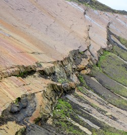 Picture: Beautifully exposed bridging relays in a branching oblique-slip fault (F on the model, below). The main scarp is 2.5m high and may mark a single rupture event.
What, for some, might look like an environmental threat can be turned into a learning asset for national good. Here, we argue that a strong case can and should be made for retaining such large-scale and superb geological sections that might otherwise be lost to future generations, along with their relevant digital social geological datasets and other and industrial records. The aim therefore for the geoscience community should be to take advantage of this opportunity and now develop what is already being referred to as the Scottish Carboniferous Research Park, or SCARP.
Learning
Such former surface mines can provide a rich visitor and/or learning experience in coal geology, illuminating aspects of a former way of life in previous generations, while also supporting high quality research into Carboniferous geology. In 2014 the Geological Society and its partner organisations celebrated the unique geological heritage of the British Isles by launching a list of ‘100 Great Geosites’ for Earth Science Week Site categories, including those of educational, industrial and economic importance (e.g. the National Mining Museum Scotland), and those of historical & scientific importance are celebrated.
Across the UK, excavations resulting from the extraction of economic mineral resources are numerous but, perhaps surprisingly, only a handful of those are designated geosites. Spireslack and Mainshill Wood opencast surface coal mines could have been ideal for all of the three Geosite categories above, but were not available or accessible for public promotion at that time.
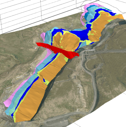
Picture: Digital reconstruction of the coals extracted from the Spireslack OSM; each of the principal coals is coloured separately. Note the tight folding revealed NE of the modelled fault (red plane).
Spireslack
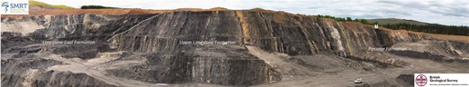
Spireslack presents a semi-continuous, almost kilometre-long, vertical high-wall section locally exposing a thickness of over 130m of Carboniferous late Viséan to early Namurian Pendleian strata, including the whole of the Limestone Coal Formation - one of the main coal-producing units in Central Scotland. These coal-bearing strata represent a typically fluvio-deltaic sedimentary facies, with the Upper and Lower Limestone formations above and below representing more marine-influenced facies with fossil-rich limestone units. At least five narrow basaltic dykes cut the section, intruded around 58-60 million years ago in the Palaeocene (just prior to Atlantic opening).
As a result of sinistral transpressive deformation in the mid- to late-Carboniferous, strata at Spireslack now dip south-eastwards at c. 30-40° across the canyon, defining one limb of a broad synclinal fold. This is revealed by the digital reconstruction of seams drawn from BGS data relating to both the opencast operations and early 20th Century underground workings. Evidence of the earlier 19th/20th Century mining practice is still visible in the high wall face where intact (but somewhat crushed) pillars or ‘stoops’ of the Muirkirk Nine Foot Coal are juxtaposed laterally with packed mine waste (in collapsed room or short wall workings).
Folding was accompanied by faulting, the effects of which are clearly seen on the south-dipping limestone pavement (Top Hosie), forming the northwest back-wall of the site where stunningly detailed exposures of bridging relays link to oblique-slip faults. Sinistral strike-slip movements dominate the fault-related deformation affecting these rocks. The scale of the high-wall section further reveals the curviplanar style of faulting that disrupts the stratigraphy.
Initial research projects are using the digitally reconstructed coal seam maps to build ‘real’ fault frameworks and stratigraphic models that can be used to test reservoir simulations or the forward modelled seismic response, all in a rock volume at Spireslack whose internal architecture is well understood.
Picture: Composite image of over 400m of Namurian strata exposed as vertical layers in the Mainshill Wood OSM; looking WSW, the back wall section is c. 75m high. The white dotted line indicates truncation of the vertical strata by complex faulting in a transpressive flower structure to the left; the thick Manson Coal seams (M) are prominent at the right hand end of the wall.
Mainshill Wood
Mainshill Wood OSM presents a continuous lateral section through over 400m of Namurian strata that include the Limestone Coal Formation, the overlying Upper Limestone Formation and most of the Passage Formation. It is very unusual for such a thickness of Carboniferous strata to be exposed in one opencast excavation. This is because many of the strata are now arranged vertically, or nearly so - a unique feature of this site.
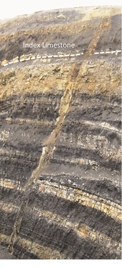
The section in the Limestone Coal Formation is so disturbed by faulting and folding that arguably the most significant feature of interest for conservation is the geological structure, rather than the exposed stratigraphy; though the latter includes at least 11 locally named coal seams, many of which are not exposed at surface anywhere else in Scotland. The section in the Upper Limestone Formation exposes all of the known Carboniferous marker limestones in the Midland Valley of Scotland, namely the Index, Huntershill (Birchlaw), Lyoncross (Tibbie Pagan’s), Orchard, Calmy (Blue Tour) and Plean limestones as well as the Ellenora and Gill coals. All of these units could eventually be safely examined at close quarters given carefully designed partial restoration - an important access issue that BGS and SMRT will carefully consider as plans for these sites mature.
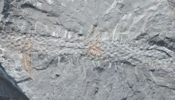
Picture: Preserved lycopsid root, Stigmaria, c. 6 cm wide, Mainshill Wood OSM.
The section in the Passage Formation at Mainshill Wood is utterly unique and known otherwise only from the records of a few boreholes drilled to prove deep coal seams. Key features of the succession here are the three thick Manson Coal seams (c. 9m in all), and associated marine mudstones with conspicuous shells. No natural exposures of the Manson strata exist, and normally in Central Scotland the Passage Formation contains a few coal seams up to about 30cm thick. The atypical thicknesses of coal-bearing strata accommodated in the depositional basin here suggests an area of more active localised subsidence, but remote from the influence of river channels bringing in sand.
It is perhaps not surprising that if such tectonic conditions were responsible for the localised subsidence, then similar controls might continue to be reflected in the subsequent deformation that gave rise to the vertical, and intensely folded and faulted strata. Near the southern back wall of the site, Limestone Coal Formation strata define a series of complex folds and associated faults in a transpressive positive flower structure - another unique aspect of this site. The junction between the complexly folded strata and the more regularly vertical strata is clearly visible and marked by a conspicuous shear zone where the original continuity of the rock layers is virtually destroyed.
Environmental change
The Carboniferous sedimentary rock types present on these sites represent cycles of environmental change, ranging from shallow tropical seas, to advancing deltas and floodplains as relative sea-level fell in coastal areas linked with development of river channels, tropical soils and tropical swamp forest. These ‘cyclic’ changes were symptomatic of sea-level changes at this time in the Carboniferous, some 330 to 315 million years ago. 
Picture: Iron ore won from these late-18th Century bell-pits sustained the short-lived Glenbuck Ironworks until 1813. The anthropogenic mounds of excavated waste are up to 20m in diameter.
Rock types readily accessible for learning and research include marine limestone with abundant visible fossil shells and trees, marine and lacustrine mudstone, burrowed siltstone and sandstone, cross-bedded and channelled sandstone, flat bedded siltstone and sandstone and rooted seat-rocks (soils), and coal. Sideritic ironstone also occurs as thin beds and nodules in the mudstone and as fist- to football-sized nodules in the rooted seat-rocks. In fact, some of the earliest mining activity in bell pits at Glenbuck exploited these ironstones for the short-lived Glenbuck Ironworks (1795 -1813).
Geology at the Spireslack and Mainshill Wood OSMs delivers unique man-made exposure on a scale unparalleled in nature; BGS is already coming together with colleagues at Aberdeen, Edinburgh, Heriot Watt, Keele, Leeds and Strathclyde Universities, and in the Geotechnical and Energy sectors, to examine and promote this hugely rich and diverse resource for learning, research and professional development. In such large sites, there is ample scope in the future for colleagues from other Universities and organisations to participate as well.
Bedrock in Central Scotland is generally concealed by thick unconsolidated Quaternary deposits and hence accessible. Informative exposures of such strategically important Carboniferous strata are thus rare and limited in scope, even in the region’s various Sites of Special Scientific Interest (SSSI) and other Geodiversity sites. By exploiting the data collected during underground and surface mining operations that are now held by BGS, the geological community can conceive of a wide spectrum of internationally significant new research that can be pursued and monitored in a volume of rocks where the essential stratigraphic and structural architecture is already well constrained.
The Spireslack canyon is a window that can help validate sub-surface interpretations deduced from state-of-the-art seismic and other geophysical methods; the geological applicability of 3-D sub-surface planning methodologies and energy resource management can also be road-tested at SCARP.
Opportunity
 This is a truly exciting opportunity to deliver a natural rock laboratory for university and industry training and research. Held in trust, responsibly conserved, and with safe maintained access for future generations, SCARP could provide that 3D laboratory and learning platform for Masters and undergraduate students, combined with a rich visitor experience – especially if supported by, and integrated with, local community goals and access for schools.
Picture: Palaeocene basaltic dyke c.3m wide, cutting Limestone Coal Formation strata; the folded sandstone at the centre-right records collapse post-mining, Spireslack OSM.
Such a restored landscape feature can be designed to provide diversity of managed access for geological and other fieldwork, perhaps partially addressing fieldwork and mining issues raised recently by Mike Harris (Geoscientist 25.6), even making fieldwork more accessible – as called for in ‘Getting Out more’ by Alison Stokes and Christopher Aitchison (Geoscientist 25.4).
Natural, cultural and geological heritage synergy is very strong and best viewed as a complete package; opportunities to develop other complementary activities such as cycling, climbing walls, renewable energy and forestry abound. The BGS and SMRT intend to work with others to unlock more of the secrets of these sites through video footage – see www.youtube.com/watch?v=1um_V5Rheqw - and make a digital sub-surface accessible to all.
Acknowledgements - further information
*Graham Leslie: BGS in Scotland, The Lyell Centre, Edinburgh EH14 4AP: [email protected].
**Mike Browne: BGS in Scotland, The Lyell Centre, Edinburgh EH14 4AP & Scottish Geodiversity Forum. Published with the permission of the Executive Director, British Geological Survey. Download details of the Carboniferous stratigraphic succession of Great Britain at: http://nora.nerc.ac.uk/3235/1/RR07001.pdf. Spireslack and Mainshill Wood are currently owned and administered by SMRT; BGS gratefully acknowledge the support of SMRT in accessing these sites to gather information in support of SCARP.