Product has been added to the basket

Greenly's geological map of Anglesey

Edward Greenly in his late thirties

Jack Treagus investigates the tangled story behind a map of some very tangled rocks.


Geoscientist 20.4 April 2010


It is 100 years since Edward Greenly completed the fieldwork for the 1:63,360 geological map of Anglesey, and 90 years since the map’s publication, complete with its 2-volume Memoir. The map was the sole work of Greenly, taking him just over 15 years to complete. Although small parts of the island had been mapped before 1894 when his work began, it was mostly unexplored territory.

This small island contains perhaps the greatest variety of geology of any comparable area in the British Isles – ranging from the Precambrian gneisses through to the Carboniferous Red Measures, with ultrabasic and acid intrusions and traversed by dykes. The whole of Anglesey is affected by glacial erosion and deposition and this received equal attention. Inland, exposure is patchy but is almost complete on the rugged, indented, coastline, some 200km in length.

Greenly was born in Bristol in 1861 and was taught at home up to the age of nine by his pacifist parents. He remembers his father, a doctor, pointing out the varieties of limestone used in the local walls and buildings, commenting on the vast age of the Earth and at this time he developed a great interest in volcanoes. In 1884 he climbed Cader Idris and reading about the columnar jointing that he had observed, he further developed his geological interests.

Greenly was sent to University College, London to study chemistry, but Professor Bonney’s classes in petrological microscopy confirmed his intention to become a geologist. At home he attempted to understand some of the geology in the Bristol district and by chance met Professor Green, who taught at the Yorkshire College, and who had become his hero through reading his “Physical Geology”. A friendship developed and they spent three weeks mapping together. Green, impressed, recommended his new protégé for a post at the Geological Survey. Even though only half way through his degree course, he was accepted and resigned from the University.


The 1920 1:63,360 map of Anglesey republished as a solid edition in 1967. Reproduced with the permission of the British Geological Survey © NERC. All rights reserved.

On reporting to the Edinburgh office in 1889, Geikie and Peach gave him a kind reception and, to his delight, he was sent to the Northwest Highlands of Scotland to work under Horne, another hero. Greenly’s first field area was on Ben Eighe, a complex zone of isoclinal folds and thrusts, and was warned by Horne that not a note, symbol or line must be put on a map that wasn’t drawn on the ground itself. Horne was most disparaging about surveyors ‘who saved shoe leather by means of opera glasses’ and of another ‘who kept his shoes dry by drawing lines from across a stream’ and others ‘who did parlour-table mapping’. Greenly suggested to Horne that some Moine schists contained original pebbles, but this was dismissed; the Moine was then regarded as reconstructed Lewisian Gneiss. However four years later the sedimentary origin of the Moine was accepted. In the company of Horne he was one of the first to see the Arnaboll and Moine Thrusts at Eriboll - though during such a fierce gale that they were forced to crawl on their hands and knees. Although a baptism of fire, Greenly said that he learnt many things on that expedition that prepared him for the Monian of Anglesey.

In 1891 Greenly married Annie Barnard, 11 years his senior, and his friend since the age of 14. He took Annie to live in primitive cottages in the wilds of northwest Scotland, while he worked for the Survey. Annie only had sight in one eye and couldn’t find employment, although (he said) she never complained. Aware of her isolation he reluctantly left the Survey in 1894, but was determined to continue with mapping at his own (and Annie’s) expense. He considered areas in Shropshire and the Lleyn Peninsula, but settled on Anglesey as it was a self-contained area that had never been mapped and contained a large area of schists, with which he was familiar.


An extract from Greenly’s mapping at 25 inches to the mile. One of the spilitic lavas in the dominant schists of this area has been coloured green by the present author. He attributed much of his outcrop-style mapping – now universally adopted - to Annie’s advice. He felt that outcrop shapes should be sympathetic to the topography – “feel the curves” – and insisted that “a map must be beautiful”.

During the First World War (he was exempted from military service) he had a permit to work along the guarded coast - but was once arrested when observed working in a deep gully. Although soon released he was set upon by an angry mob believing him to be a spy and was saved by a policeman who escorted him to the railway station.

As Greenly moved away from the simpler rocks of the Carboniferous and Ordovician he had to face the complexities of the glaucophane schists, gneisses and the Coedana granite in the centre of the island. Eventually he also had to confront the schists and quartzites of Holy Island, which he viewed with “great trepidation”. Clough visited him in 1907 and suggested that there might be repetition by nappe-like isoclinal folds within these rocks, a concept that was becoming clear in the Alps and which Clough was developing in the Dalradian. Greenly readily adopted this idea although it was later proved incorrect by Shackleton (1957) on the basis of sedimentary structures; although Greenly was aware of cross-bedding and graded bedding he would not have expected them in these older schists and quartzites.

However, Greenly became aware of the presence of the magnificent, large-scale, upright folds in these rocks when he drew the coastal section, during a perilous journey in a steam life-boat. It is clear from his beautiful drawings in the Memoir that he was also aware of the relationship of minor to major folds, and of the consistency of axial plunge of the various scales of folds. Moreover he clearly appreciated what we now call ‘refolding’ on various scales.

Greenly received many geological visitors, especially Barrow, Clough, Dakyns, Lamplugh, Horne, Kilroe and Matley. Barrow stayed for two weeks and gave great help with the schists and gneisses. He became great friends with Blake and Calloway, despite their opposing views about the Moine.

Annie Greenly was a frequent spectator, often sitting on hilltops while her husband mapped, and acted as his look-out for express trains in railway cuttings. Transport around the island, which has an intricate network of minor roads (then unpaved), was by foot, bicycle and train. Their home was a cottage that the couple had built within easy reach of Bangor station. For remoter areas Greenly took ‘country quarters’ which, as work progressed, meant being away from home for most of the year. Otherwise, Annie would go ahead by rail to find quarters in cottages, inns and farms. Annie visited Edward at weekends, bringing home-made food, often walking five miles from the nearest station. She made him send her ‘quarterly returns’, just as he would have done in the Survey, giving the linear miles of boundaries and the square miles mapped. The square mileage was often not more than 20, but his boundary mileage to the square mile was often as much as 30. It is worth noting that Greenly was one of the first geologists to outline exposures precisely on his maps.

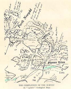
The mapping was completed after “15 years, 4 months and a fortnight” on 8 October 1910, on a remote hillside in the north of the island. He shut his map-case and embraced Annie, who was by his side. In 1920 the 1:63,360 map, delayed by the Great War, was published together with its detailed two-volume Memoir. In 1927 Annie, aged 75, died at home in his arms. Greenly later donated money to the Geological Society of London for the Annie Greenly Fund, awarded to this day for detailed geological mapping.


Sources


Greenly’s autobiography (1938. A Hand Through Time, Thos. Murby & Co, London) and Memoir to the Anglesey map (1919. The Geology of Anglesey, Memoirs of the Geological Survey of Great Britain HMSO, London, 78, 980 pp). Also: Williams T P T, The role of Annie Greenly in the elucidation of the geology of Anglesey. In: Burek, C V & Higgs, B (eds) The Role of Women in the History of Geology. Geological Society, London, Special Publications, 281, 319–324.